
 Images of the new Trump/Netanyahu Peace plan. Photo by JTA.
 On Feb. 1, 2020, Holocaust denier, Mahmoud Abbas, the “president for life” of the Palestinian Authority, gave a speech to the Arab League where he justified the latest “No” by the Arabs to a proposal for the first-ever independent Arab state in history west of the Jordan River. Given the many previous rejections of peace and partition by the Arab dictatorships (1937, 1947, 1967, 2000, 2001, 2003, and 2008), Abbas’s rejection of the Trump peace and partition plan was hardly surprising.
During his Arab League speech, Abbas – as expected – lied. He claimed that most Israelis whose ancestors were in the Diaspora in the former Soviet Union and Ethiopia are not Jewish. He also claimed that Israel could not be recognized (by the Arab dictatorships) as a Jewish state because Israel has citizens who are not Jewish. Apparently, Abbas expects the world to believe that the approximately 80 countries in the world that officially identify as either Muslim or Christian states only have Muslim or Christian citizens.
The biggest lie, however, did not necessarily come from Abbas’s mouth. It was in his hands.
In his kleptocratic hands, Abbas held up one of the many iterations of the most popular memes of the hate-Israel crowd. The “Disappearing Palestine” or “Palestine Loss of Land” maps.
These maps are such a ubiquitous part of the “Palestinian narrative” that a Google Image search under “Palestinian land” results in the first 23, and 59 of the first 70, images being some variation of these duplicitous maps.
The most common version of these maps is the below version, which has been promoted by numerous haters of Jewish sovereignty in the land of Israel; such as Juan Cole, Mondoweiss, Electronic Intifada, and the Palestinian National Council:
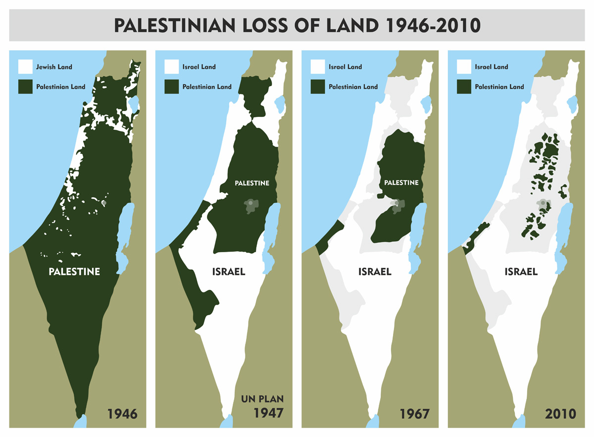
Everything about these maps is a lie. Not just a “white lie,” but the type of whopper of a lie, which would have made Pinocchio’s nose longer than Shaquille O’Neal.
First, these maps lie because they begin with the implication or express assertion (as in the map held up by Abbas during his speech) that there was a “historic Palestine” (another common lie used by the Israel-haters) that had known boundaries west of the Jordan River and south of Lebanon/Syria. That is plainly false. Before the 20th Century and the start of the British Mandate, to the extent anyone not Jewish or a Christian Zionist ever referred to a region called “Palestine,” that region never had certain boundaries and certainly never had boundaries that ended at the current borders of Syria and Lebanon to the North and the Jordan River to the East.
In fact, it was so ambiguous what geographic area may be described by the name “Palestine” – which had never been used by any polity ever in history, including the Ottoman Turks who controlled the area for 400 years before the British Mandate – that the Encyclopedia Britannica in 1911 described the ambiguity of this nebulous area sometimes called Palestine as follows:
“PALESTINE, a geographical name of rather loose application. Etymological strictness would require it to denote exclusively the narrow strip of coast-land once occupied by the Philistines, from whose name it is derived. It is, however, conventionally used as a name for the territory which, in the Old Testament, is claimed as the inheritance of the pre-exilic Hebrews; thus it may be said generally to denote the southern third of the province of Syria. Except in the west, where the country is bordered by the Mediterranean Sea, the limit of this territory cannot be laid down on the map as a definite line. The modern subdivisions under the jurisdiction of the Ottoman Empire are in no sense conterminous with those of antiquity, and hence do not afford a boundary by which Palestine can be separated exactly from the rest of Syria in the north, or from the Sinaitic and Arabian deserts in the south and east; nor are the records of ancient boundaries sufficiently full and definite to make possible the complete demarcation of the country…Taking as a guide the natural features most nearly corresponding to these outlying points, we may describe Palestine as the strip of land extending along the eastern shore of the Mediterranean Sea from the mouth of the Litany or Kasimiya River (33° 20′ N.) southward to the mouth of the Wadi Ghuzza; the latter joins the sea in 31° 28′ N., a short distance south of Gaza, and runs thence in a south-easterly direction so as to include on its northern side the site of Beersheba. Eastward there is no such definite border. The River Jordan, it is true, marks a line of delimitation between Western and Eastern Palestine; but it is practically impossible to say where the latter ends and the Arabian desert begins. Perhaps the line of the pilgrim road from Damascus to Mecca is the most convenient possible boundary.”
As confirmed by the Encyclopedia Britannica in 1911 (before anyone in the world had any antisemitic incentives to create “narratives” about Palestine), the nebulous area sometimes referred to as “Palestine” before WWI generally included parts of today’s southern Lebanon, it excluded much of the Negev Desert, and it continued “Eastward” past the Jordan River with “no definite border.”
After WWI, “Palestine” initially included all of what is today Israel and Jordan, until 1921 when the British Colonial Office lopped of 78% of the Palestine Mandate and turned that area into the never-before-in-history brand new Arab state called TransJordan (which in 1946 became Jordan, a state that is presently nearly 75% Palestinian Arab).
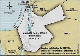
Thus, the starting point for these duplicitous “Disappearing Palestine” or “Palestine Land Loss” maps is the pretense that there was ever a “Palestine” or “Historic Palestine” with fixed borders west of the Jordan River and south of Lebanon/Syria.
This pretense is also the basis for the lie that all of the peace proposals since 1993 require the Palestinian Arabs to give up their claim to nearly 80% of “Palestine.” Setting aside that this claim ignores that Israel is on approximately 1% of the land occupied by the 23 Arab dictatorships that surround it, this lie dissembles over the fact that 78% of the original Mandate for Palestine was partitioned into a largely Palestinian Arab state back in 1921. A state where it was (and is) illegal for Jews to own any land.
Second, these maps are duplicitous because they deliberately and maliciously fail to differentiate between private property and sovereign land, all while ignoring any political or historical context.
The first map, the one typically dated “1946” is by far the most “hair on fire” lie. It is a map that depicts in white Jewish National Fund (JNF) land purchases dating roughly from the 1920s. It labels those relatively few patches of white as the “Jewish” (or Israeli) land. This map then colors in green all of the land east of the Jordan River not privately owned by the JNF before 1946 and labels all of the green land as “Palestinian” or as being “Palestine.”
FALSE. As a preliminary matter, very few Arabs (including those who later came to identify themselves as Palestinians) privately owned any of the land in green in the first map. Most of the land in that first map is the Negev Desert (which was largely uninhabited) and the then sovereign owned almost all of the land in green before 1946 (the Ottoman Empire for 400 years and the British Empire from 1917 to 1948).
Thus, an honest map comparing private Jewish or JNF land ownership (setting aside the 1939 British White Paper prohibition on Jewish land purchases) and private Arab land ownership of land east of Jordan River would look very different. Such a map would show relatively little land as “Palestinian” …, which is likely why the propagandists who came up with these maps avoid such an “apples to apples” comparison.
The first map is also duplicitous because it implies that as of 1946 the land in white (the JNF-owned or Jewish land) was not part of “Palestine,” while the land in green was “Palestine.” Of course, that is another fabrication. In 1946, all of the land west of the Jordan River was under the control of the British, and no matter who did or did not privately own it; all of the land in the first map was part of the British Mandate for Palestine.
Third, these maps are duplicitous because the second map does not represent any land owned or controlled – ever – by any Palestinian Arab polity. Instead, it only represents the non-binding partition plan adopted by the United Nations General Assembly in 1947. A proposed partition plan and map – accepted by the Jews and rejected by the Arabs – who chose a genocidal war to destroy Israel instead. Thus, this second map lies because (a) it falsely represents that this land in green was sovereign Palestinian Arab land; and (b) it ignores why this lack of control never happened – the Arab rejection of the 1947 partition plan and their dictators’ decision to choose the results of all-out war instead.
Fourth, these maps continue to lie, mislead and muddle because the next map – mislabeled 1967 – actually shows the 1949 “armistice lines” or “green lines” (the cease-fire lines created when Israel and the 5 Arab armies that attacked it stopped fighting in 1949). The Arab dictatorships were the ones who insisted the green line was not a permanent border. The precarious green line, which left Israel barely 9 miles wide at its narrowest point, was essentially Israel’s border from 1949 through June of 1967. The big lie, however, in this map is what the mendacious anti-Israel mapmakers and propagandists depict being on the other side of the green line, in Judea and Samaria and the Gaza Strip – yet another duplicitous claim that the land in green is “Palestine” or “Palestinian.”
A Palestinian Arab polity or entity, however, never controlled these lands between 1947 and 1967. Both territories were occupied by invading Arab armies after the armistice was declared in 1949, the Gaza Strip by Egypt, and Judea and Samaria by Jordan (after both of these territories were ethnically cleansed of the Jews who lived there).
The last map – usually labeled “2010” or “2012” – is in some ways, the only honest map. At least it could arguably be honest if it appeared on its own.
What the final map accurately depicts in green is the first time ever in history that a separate Arab polity had any political control of any land west of the Jordan River. As a part of the 1993 Oslo Accords, Israel handed over to the Palestinian Authority administrative control of all of Gaza and of large sections of Judea & Samaria (where over 90% of the Arabs residing in Judea & Samaria live). This grant of administrative control, however, was conditioned on the Palestinian Authority embracing peace, teaching peace, eschewing terrorism and antisemitic incitement and negotiating in good faith in final status talks.
What this final map ignores, and therefore lies about by omission, is why there remains a Palestinian Authority – and no first of its kind in history country called “Palestine.”
It ignores Yassar Arafat’s rejection of a Palestinian State in 2000 and 2001. It ignores the brutal Intifada, the murder of over a 1000 Jews, which Arafat launched after he rejected – without a counteroffer – the independent state offered to him in all of Gaza and over 90% of Judea & Samaria. It ignores the offers subsequently rejected by Abbas, including former Prime Minister Ehud Olmert’s unrequited offer in 2008 of an independent Arab state in all of Gaza and over 95% of Judea & Samaria. In addition, it ignores the Palestinian Authority’s continued support of terrorism, its “pay to slay” program, and the virulent antisemitic incitement and hatred it funds and promotes.
All in all, these oft-used maps, which are not only ubiquitous among all anti-Israel groups, advocates and websites – they were just used by the Palestinian Authority’s kleptocrat-in-chief, Mahmoud Abbas, as a prop to justify yet another Palestinian Arab rejection of a peace/partition plan – are nothing but a pack of lies.
These maps conflate private property with political control. They confuse sovereignty with proposed partition plans. They misrepresent the actual history of the region, what countries or empires controlled it, and they completely lie about the original boundaries for the geographic area or territory called “Palestine” as well as pretend that the majority Palestinian Arab state (Jordan) that sits on nearly 80% of that territory doesn’t exist.
The reality is that there is a very good reason for why one of the most often used memes by the Israel-haters and by those who support Palestinian Arab rejectionism is so egregiously dishonest and misleading. It is because the entire anti-Israel “narrative” is just that, a “narrative.” A story. It is not historical or factual. It’s an antisemitic tale told by people who care much more about denying the Jewish people any sovereignty in their indigenous homeland than they care about the truth, facts or history.
All people of good conscience should call out the dishonesty and mendacity of these maps. Doing so is not only honest; it will ultimately help the people living under the day-to-day control of Hamas and the Palestinian Authority. Just as the German people’s ultimate rejection after WWII of their false narratives of hate and antisemitism led to peace and prosperity for the German people, the same could happen for the Palestinian Arabs. However, that will never happen as long as there are so many people who tolerate these lies and do not call them out for their deliberate and mendacious purpose – to promote the destruction of Israel.


 More news and opinions than at a Shabbat dinner, right in your inbox.